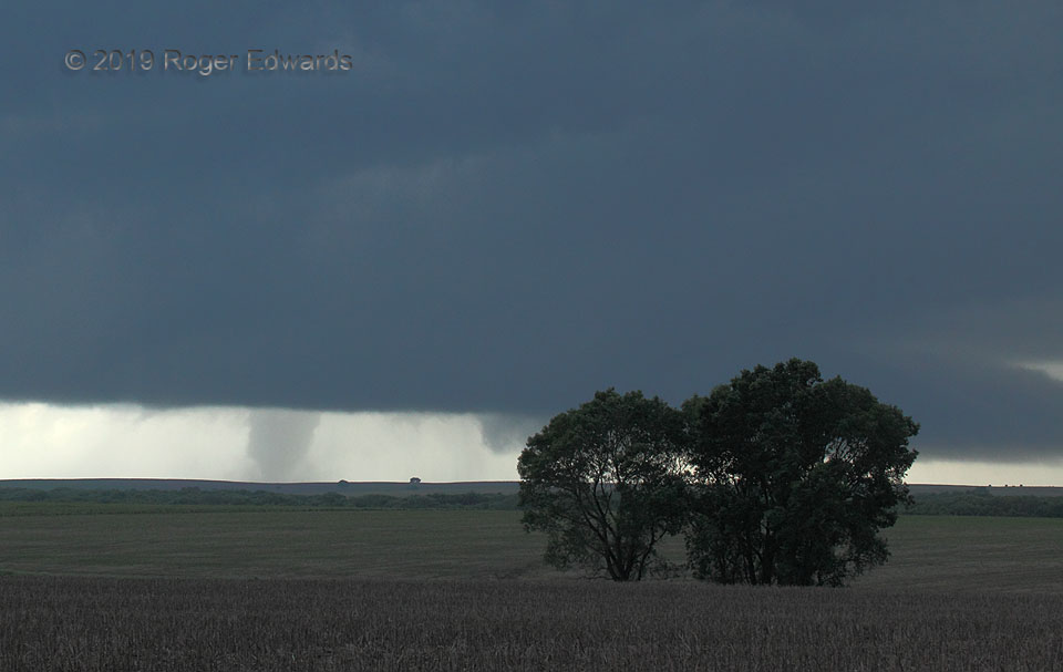
 The final minute of the 2019 Tipton, KS tornado found it still robust, but nearly completely shed from the rest of the storm in a common process. Within less than another few clicks of the camera shutter, the tornado was gone—not in a more-typical rope-out, but instead, simply vanished. The condensation disappeared in seconds, and the remaining dust settled irrotationally. That was an unusual ending in my experience, but one reported by several spotters, chasers and other eyewitnesses over the decades for previously strong, relatively long-lived tornadoes. The “orphaned” circulation almost instantly got deprived of its source of instability and/or vorticity, and that was that! Cyclic supercells, like this, often shed old mesocyclones to their back side, sometimes while still tornadic. New mesocyclones often form, and in this case, one did, manifest visually by an early-stage wall cloud behind the trees, with tail cloud at right. We were near a great position were the storm to produce another, but it did not. The storm was moving too far into a cooler, more-stable part of outflow-reinforced warm-frontal zone that had supplied boundary-layer vorticity for its tornadic spree across parts of northern Kansas.
5 SSW Glen Elder KS (28 May 19) Looking SW
39.4225, -98.3275
RADAR
The final minute of the 2019 Tipton, KS tornado found it still robust, but nearly completely shed from the rest of the storm in a common process. Within less than another few clicks of the camera shutter, the tornado was gone—not in a more-typical rope-out, but instead, simply vanished. The condensation disappeared in seconds, and the remaining dust settled irrotationally. That was an unusual ending in my experience, but one reported by several spotters, chasers and other eyewitnesses over the decades for previously strong, relatively long-lived tornadoes. The “orphaned” circulation almost instantly got deprived of its source of instability and/or vorticity, and that was that! Cyclic supercells, like this, often shed old mesocyclones to their back side, sometimes while still tornadic. New mesocyclones often form, and in this case, one did, manifest visually by an early-stage wall cloud behind the trees, with tail cloud at right. We were near a great position were the storm to produce another, but it did not. The storm was moving too far into a cooler, more-stable part of outflow-reinforced warm-frontal zone that had supplied boundary-layer vorticity for its tornadic spree across parts of northern Kansas.
5 SSW Glen Elder KS (28 May 19) Looking SW
39.4225, -98.3275
RADARDeeply Occluded Tornadic Mesocyclone
The final minute of the 2019 Tipton, KS tornado found it still robust, but nearly completely shed from the rest of the storm in a common process. Within less than another few clicks of the camera shutter, the tornado was gone—not in a more-typical rope-out, but instead, simply vanished. The condensation disappeared in seconds, and the remaining dust settled irrotationally. That was an unusual ending in my experience, but one reported by several spotters, chasers and other eyewitnesses over the decades for previously strong, relatively long-lived tornadoes. The “orphaned” circulation almost instantly got deprived of its source of instability and/or vorticity, and that was that! Cyclic supercells, like this, often shed old mesocyclones to their back side, sometimes while still tornadic. New mesocyclones often form, and in this case, one did, manifest visually by an early-stage wall cloud behind the trees, with tail cloud at right. We were near a great position were the storm to produce another, but it did not. The storm was moving too far into a cooler, more-stable part of outflow-reinforced warm-frontal zone that had supplied boundary-layer vorticity for its tornadic spree across parts of northern Kansas.
5 SSW Glen Elder KS (28 May 19) Looking SW
39.4225, -98.3275
RADAR