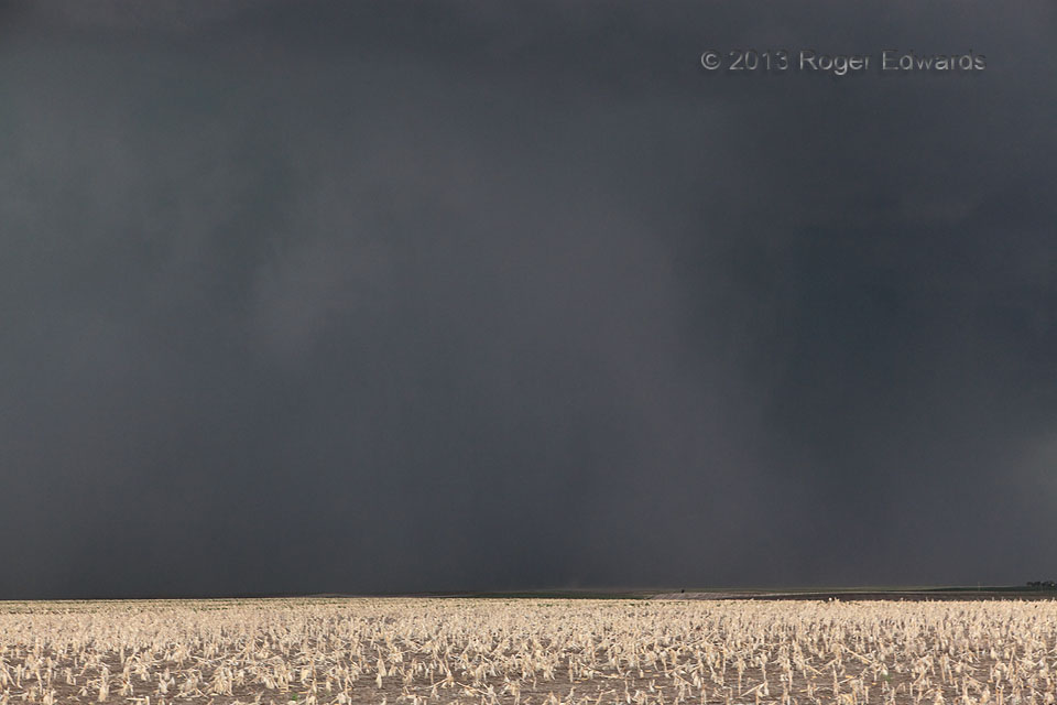
 [Part 1 of 2] Following our observation of an intensely rotating wall cloud in extreme eastern Wyoming, the mesocyclone wrapped deeply into this ominous HP (heavy-precipitation) form, spawning a stout tornado that traveled 20 miles east-southeastward from north of LaGrange, WY, to near Harrisburg, NE. You’re looking straight at the tornado, roughly mid-path. Can you see it? Rolling along a road south then southeast of the mesocyclone, we couldn’t make out anything meaningful in there for quite some time. Then, Elke showed me a brightly red/green, 80+ kt gate-to-gate, lowest-tilt velocity signature on radar, prompting me to pull over fast! I knew this storm was producing an intense tornado, and easily could tell where, given: 1) our position relative to a slight mental shift of that minutes-old radar signature, and 2) the visible, furiously turning, tightly focused cage of rain and hail rotating around it. One thing that helped was shooting some digital photos of where I knew the tornado to be hiding, noticing it easier on the LCD view, then looking up again to spot the tornado better with my eyes! The tornado is the dark, barrel-shaped form at lower center, surrounded by a dense precip and cloud collar. Other dark areas to its left represented relative gaps in the front wall of precip. This was one of just a very few brief, murky views I had of the condensation vortex, but this was enough to make a confident report once I got in sufficient cellular coverage. What about that spot of dust in front and just to the right of the tornado? That was a gustnado, a rotating dust plume in outflow winds (in this case, a wrapping gust front on the outer edge of the rain), not connected to the cloud above, and not a tornado. [Part 2]
11 NW Harrisburg NE (22 Jun 13) Looking NW
41.6411, -103.9573
RADAR
[Part 1 of 2] Following our observation of an intensely rotating wall cloud in extreme eastern Wyoming, the mesocyclone wrapped deeply into this ominous HP (heavy-precipitation) form, spawning a stout tornado that traveled 20 miles east-southeastward from north of LaGrange, WY, to near Harrisburg, NE. You’re looking straight at the tornado, roughly mid-path. Can you see it? Rolling along a road south then southeast of the mesocyclone, we couldn’t make out anything meaningful in there for quite some time. Then, Elke showed me a brightly red/green, 80+ kt gate-to-gate, lowest-tilt velocity signature on radar, prompting me to pull over fast! I knew this storm was producing an intense tornado, and easily could tell where, given: 1) our position relative to a slight mental shift of that minutes-old radar signature, and 2) the visible, furiously turning, tightly focused cage of rain and hail rotating around it. One thing that helped was shooting some digital photos of where I knew the tornado to be hiding, noticing it easier on the LCD view, then looking up again to spot the tornado better with my eyes! The tornado is the dark, barrel-shaped form at lower center, surrounded by a dense precip and cloud collar. Other dark areas to its left represented relative gaps in the front wall of precip. This was one of just a very few brief, murky views I had of the condensation vortex, but this was enough to make a confident report once I got in sufficient cellular coverage. What about that spot of dust in front and just to the right of the tornado? That was a gustnado, a rotating dust plume in outflow winds (in this case, a wrapping gust front on the outer edge of the rain), not connected to the cloud above, and not a tornado. [Part 2]
11 NW Harrisburg NE (22 Jun 13) Looking NW
41.6411, -103.9573
RADARDanger in the Darkness
[Part 1 of 2] Following our observation of an intensely rotating wall cloud in extreme eastern Wyoming, the mesocyclone wrapped deeply into this ominous HP (heavy-precipitation) form, spawning a stout tornado that traveled 20 miles east-southeastward from north of LaGrange, WY, to near Harrisburg, NE. You’re looking straight at the tornado, roughly mid-path. Can you see it? Rolling along a road south then southeast of the mesocyclone, we couldn’t make out anything meaningful in there for quite some time. Then, Elke showed me a brightly red/green, 80+ kt gate-to-gate, lowest-tilt velocity signature on radar, prompting me to pull over fast! I knew this storm was producing an intense tornado, and easily could tell where, given: 1) our position relative to a slight mental shift of that minutes-old radar signature, and 2) the visible, furiously turning, tightly focused cage of rain and hail rotating around it. One thing that helped was shooting some digital photos of where I knew the tornado to be hiding, noticing it easier on the LCD view, then looking up again to spot the tornado better with my eyes! The tornado is the dark, barrel-shaped form at lower center, surrounded by a dense precip and cloud collar. Other dark areas to its left represented relative gaps in the front wall of precip. This was one of just a very few brief, murky views I had of the condensation vortex, but this was enough to make a confident report once I got in sufficient cellular coverage. What about that spot of dust in front and just to the right of the tornado? That was a gustnado, a rotating dust plume in outflow winds (in this case, a wrapping gust front on the outer edge of the rain), not connected to the cloud above, and not a tornado. [Part 2]
11 NW Harrisburg NE (22 Jun 13) Looking NW
41.6411, -103.9573
RADAR