SkyPix

A digital photographic storybook of clouds, weather and water by Roger Edwards.

  • Home
  • Newest Posts
  • Galleries
    • Aerial
    • All Hail
    • Burnscapes
    • Daytime Lightning
    • Floods
    • Fog and Mist
    • Gallery of Outflow
    • Hurricane Andrew
    • Mini Cloud Atlas
    • Night Lightning
    • Mostly Okie Winters
    • Sunsets and Sunrises
    • The Majestic Supercell
    • Tornadoes
    • Unusual Weather Damage
    • Visual Effects
    • Wall Cloud Wall
    • Water Works
  • About
  • F.A.Q.
  • Contact

Classic Early-Stage Supercell

2024-07-06 By Roger Edwards

Classic Early-Stage Supercell

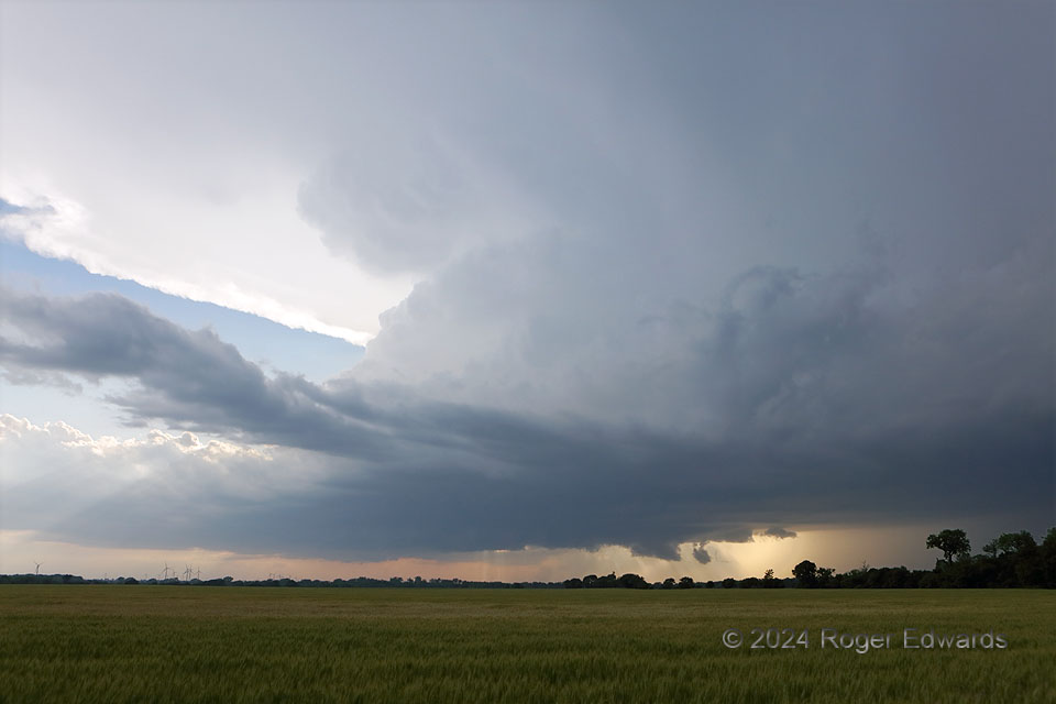
Seldom does a supercell look more like the classical textbook depiction than this.  One clearly can see the wide updraft base across the lower middle (with small wall cloud), forward-flank core behind the trees at right, flanking line and tilted towers in the left middle half, an “inflow tail” spreading anvil above, and even overturning “knuckles” between the top of the flanking towers and anvil.  A continuous connection with other, earlier-developing storms to the north, near Wichita, isn’t visible here, making this supercell a “tail-end Charlie” as well.  Seconds after I shot this, a brightly forked CG lightning discharge from the anvil hit one of the trees at leftmost  rear, ensuring the rest of my viewing at this location would be from inside my mobile Faraday cage.  The storm soon assumed a heavy-precip “stack of plates” structure, dropping damaging hail in a swath southeastward through Ponca City and western Osage County.

2 NW Braman OK (15 May 24) Looking WNW
36.9327, -97.3549

Filed Under: The Majestic Supercell Tagged With: Braman, clouds, convection, Great Plains, knuckle clouds, landscapes, Oklahoma, storms, supercells, tail cloud, thunderstorms, wall clouds, weather

Previous: Charged Core
Next: Pretornadic Wall Cloud and Separate Cone

About

Welcome to SkyPix, an online photo book of clouds, weather and water by Roger Edwards. As in a printed coffee-table book, every image has its own page with a unique story. After all, meaningful photography is much more than just picture-taking; it is visually rendering a moment in place and time from a perspective like none other. As a scientist and an artist, I hope my deep passion for the power and splendor of our skies and waters shines through in these pages. If you are a cloud and weather aficionado, outdoor enthusiast, outdoor or nature photographer, art lover, or anyone who craves learning, enjoy...

More

Further images from this photographer may be found at:
Roger Edwards Image of the Week
Roger Edwards Digital Galleries
Storms Observed Chase BLOG

Copyright © 2025 ROGER EDWARDS SKYPIX.PHOTOGRAPHY ALL RIGHTS RESERVED. · Design by INSOJOURN Design and Images · WordPress · Log in