SkyPix

A digital photographic storybook of clouds, weather and water by Roger Edwards.

  • Home
  • Newest Posts
  • Galleries
    • Aerial
    • All Hail
    • Burnscapes
    • Daytime Lightning
    • Floods
    • Fog and Mist
    • Gallery of Outflow
    • Hurricane Andrew
    • Mini Cloud Atlas
    • Night Lightning
    • Mostly Okie Winters
    • Sunsets and Sunrises
    • The Majestic Supercell
    • Tornadoes
    • Unusual Weather Damage
    • Visual Effects
    • Wall Cloud Wall
    • Water Works
  • About
  • F.A.Q.
  • Contact

Campo-21 Zoom

2021-07-26 By Roger Edwards

Campo-21 Zoom

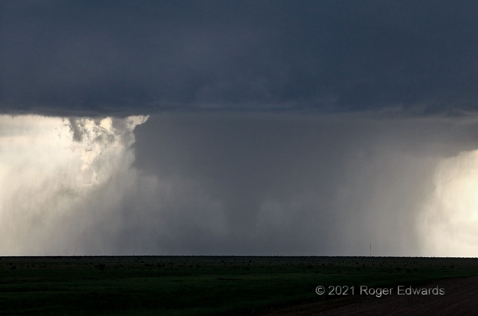
A thick, densely rain-wrapped tornado from a rather high-based High Plains storm obviously can happen (here it is and here’s another from 8 years earlier!), but isn’t common in my experience.  In the southeast and sometimes lower Plains, where smaller dewpoint depressions and less evaporative cooling happen, tornadoes can (and often do) generate within dense precip, and can last a long time.  Typically, on the higher terrain, drier inflow air and higher ambient cloud bases away from the mesocyclone support stronger evaporative cooling, which can handicap tornado development and longevity via cold outflow, when a lot of precip is produced.  Instead, this one formed within an already rain-encircling subcloud mesocyclone, either ignoring or perhaps even benefiting from the added moisture of the rain, and somehow, without enough cooling to stabilize the environment to degrees disfavoring tornadogenesis.   We had a hard time seeing the tornado visually, except for this brief window of more-obvious form and a glance at the LCD screen containing this photo, together affirming the presence of a stout-looking tornado inside the “bear’s cage”.   [Spotters:  shoot photos, and use that LCD in real time!  It really can help to reveal features and reduce uncertainty.]  Despite the robust form, the tornado crossed grasslands and ranchland, and did not cause damage that would indicate its true intensity.

13 S Pritchett CO (29 May 21) Looking WSW
37.1487, -102.8511

RADAR

Filed Under: Tornadoes Tagged With: Campo, clouds, Colorado, convection, Great Plains, landscapes, Pritchett, storms, supercells, thunderstorms, tornado, wall clouds, weather

Previous: Eloy Electricity
Next: Route 66 Arcus

About

Welcome to SkyPix, an online photo book of clouds, weather and water by Roger Edwards. As in a printed coffee-table book, every image has its own page with a unique story. After all, meaningful photography is much more than just picture-taking; it is visually rendering a moment in place and time from a perspective like none other. As a scientist and an artist, I hope my deep passion for the power and splendor of our skies and waters shines through in these pages. If you are a cloud and weather aficionado, outdoor enthusiast, outdoor or nature photographer, art lover, or anyone who craves learning, enjoy...

More

Further images from this photographer may be found at:
Roger Edwards Image of the Week
Roger Edwards Digital Galleries
Storms Observed Chase BLOG

Copyright © 2025 ROGER EDWARDS SKYPIX.PHOTOGRAPHY ALL RIGHTS RESERVED. · Design by INSOJOURN Design and Images · WordPress · Log in