SkyPix

A digital photographic storybook of clouds, weather and water by Roger Edwards.

  • Home
  • Newest Posts
  • Galleries
    • Aerial
    • All Hail
    • Burnscapes
    • Daytime Lightning
    • Floods
    • Fog and Mist
    • Gallery of Outflow
    • Hurricane Andrew
    • Mini Cloud Atlas
    • Night Lightning
    • Mostly Okie Winters
    • Sunsets and Sunrises
    • The Majestic Supercell
    • Tornadoes
    • Unusual Weather Damage
    • Visual Effects
    • Wall Cloud Wall
    • Water Works
  • About
  • F.A.Q.
  • Contact

Brownwood Fooler

2023-10-20 By Roger Edwards

Brownwood Fooler

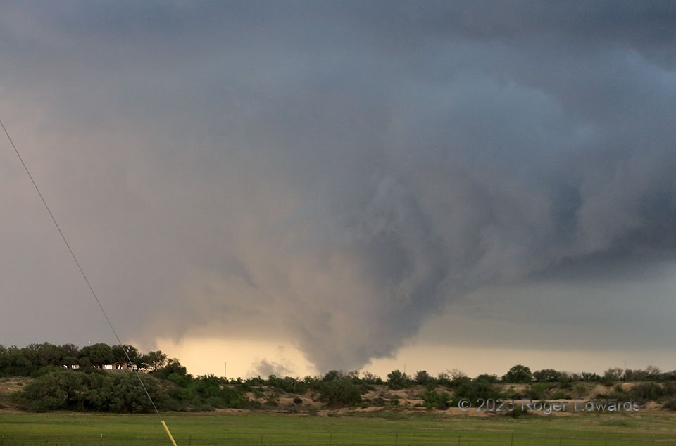
The year’s second trek to the Edwards Plateau and Hill Country (still more to come in June) yielded a big, messy supercell that passed right over Brownwood, with baseball-sized hail and separate measured gusts of 65 and 64 knots, 13 minutes apart.  While trying to stay ahead of the gnarly storm, which seemed increasingly outflow-dominant, I made a wrong turn southeast instead of east in town.  Though frustrating in the moment, that worked out well.  Trying to pop out of town and gain a view around a low ridge, I looked back at left rear and spotted this stunning, scuddy, yet highly suspicious feature, which was slowly but definitely rotating, in the “right” spot (a low-level mesocyclone) and in an active tornado warning.  I was in outflow, behind the rear-flank gust front.  The key here with the rotation was “slowly”.  How slow is too slow?  Either this was a broad, weak tornado, or a rotating, “ground scraping” and cone-shaped wall cloud whose bottom was not visible below the ridge.   Within five minutes, outflow undercut the formation, and it lost rotation while dissipating.  Later consultation with the San Angelo NWS’ warning-coordination meteorologist determined that there was no damage associated with this feature.  Because of that, the lack of stronger rotation and a large shadow of doubt, we decided it would not get logged as a tornado.  Even though that meant the warning didn’t technically verify, honesty with available evidence was more important.

4 SE Brownwood TX (6 May 23) Looking N
31.6728, -98.9407

Filed Under: Wall Cloud Wall Tagged With: Brownwood, clouds, convection, Hill Country, landscapes, nontornado, storms, supercells, Texas, thunderstorms, wall clouds, weather

Previous: Layers of Cloud and Wind
Next: Transitions

About

Welcome to SkyPix, an online photo book of clouds, weather and water by Roger Edwards. As in a printed coffee-table book, every image has its own page with a unique story. After all, meaningful photography is much more than just picture-taking; it is visually rendering a moment in place and time from a perspective like none other. As a scientist and an artist, I hope my deep passion for the power and splendor of our skies and waters shines through in these pages. If you are a cloud and weather aficionado, outdoor enthusiast, outdoor or nature photographer, art lover, or anyone who craves learning, enjoy...

More

Further images from this photographer may be found at:
Roger Edwards Image of the Week
Roger Edwards Digital Galleries
Storms Observed Chase BLOG

Copyright © 2025 ROGER EDWARDS SKYPIX.PHOTOGRAPHY ALL RIGHTS RESERVED. · Design by INSOJOURN Design and Images · WordPress · Log in