 The rising dust under this ragged but rapidly rotating wall cloud also was moving around in a closed circulation—just not as visually intensely as the clouds above. If I had to guess, it was near the margins of the lower EF0 wind threshold of 65-mph three-second gusts, but of course this storm did not have a mobile radar or in situ anemometer involved, to establish better confidence. The vortex was pulling dust from a field wettened by rain from the supercell‘s forward-flank core, which is no easy feat. Yet it never obviously tightened more than this, nor developed visible suction vortices, nor a funnel, nor a more obvious, dense, dusty tornadic swirl. What was it, weak tornado or just a “mesocyclone on the ground”? According to the edition of the AMS Glossary available as of this writing, the latest “official” definition of a tornado is: “A rotating column of air, in contact with the surface, pendant from a cumuliform cloud, and often visible as a funnel cloud and/or circulating debris/dust at the ground.” By that standard, which no longer uses the subjective word “violent” nor ever established the lower EF0 threshold for wind, the answer would be yes. However, a strictly literal reading of that definition could allow for a ridiculous 20-mph “tornado”!
Many older meteorologists and storm observers steeped in 1970s–1980s chasing jargon use the term “tornado cyclone” to describe such features, though that often has implied the presence of a bonafide, verifiable tornado within the broader vortex. Regardless, this sort of clearly surface-based, potentially damaging, but not obviously tornadic circulation occupies a spectral netherworld between mesocyclone and tornado, where subjectivity reigns. Such on-the-margins circulations also are rather common in my experience, and probably more so in the real world than we’d like to admit. Whether it counts as a tornado is often up to the arbitrary and capricious whim of the observer. If he wants a notch in the gun, he counts it; if he’s a scientific, skeptical type like me, he does not (I did not). Yet I could be wrong! As it occurred in open country and did no known damage, we’ll probably never know. The lesson: a spectrum can get messy around subjective thresholds drawn on it.
2 NW Renfrow OK (6 May 15) Looking NW
36.9469, -97.6785
The rising dust under this ragged but rapidly rotating wall cloud also was moving around in a closed circulation—just not as visually intensely as the clouds above. If I had to guess, it was near the margins of the lower EF0 wind threshold of 65-mph three-second gusts, but of course this storm did not have a mobile radar or in situ anemometer involved, to establish better confidence. The vortex was pulling dust from a field wettened by rain from the supercell‘s forward-flank core, which is no easy feat. Yet it never obviously tightened more than this, nor developed visible suction vortices, nor a funnel, nor a more obvious, dense, dusty tornadic swirl. What was it, weak tornado or just a “mesocyclone on the ground”? According to the edition of the AMS Glossary available as of this writing, the latest “official” definition of a tornado is: “A rotating column of air, in contact with the surface, pendant from a cumuliform cloud, and often visible as a funnel cloud and/or circulating debris/dust at the ground.” By that standard, which no longer uses the subjective word “violent” nor ever established the lower EF0 threshold for wind, the answer would be yes. However, a strictly literal reading of that definition could allow for a ridiculous 20-mph “tornado”!
Many older meteorologists and storm observers steeped in 1970s–1980s chasing jargon use the term “tornado cyclone” to describe such features, though that often has implied the presence of a bonafide, verifiable tornado within the broader vortex. Regardless, this sort of clearly surface-based, potentially damaging, but not obviously tornadic circulation occupies a spectral netherworld between mesocyclone and tornado, where subjectivity reigns. Such on-the-margins circulations also are rather common in my experience, and probably more so in the real world than we’d like to admit. Whether it counts as a tornado is often up to the arbitrary and capricious whim of the observer. If he wants a notch in the gun, he counts it; if he’s a scientific, skeptical type like me, he does not (I did not). Yet I could be wrong! As it occurred in open country and did no known damage, we’ll probably never know. The lesson: a spectrum can get messy around subjective thresholds drawn on it.
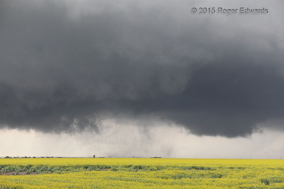
2 NW Renfrow OK (6 May 15) Looking NW
36.9469, -97.6785Between a Mesocyclone and a Tornado
The rising dust under this ragged but rapidly rotating wall cloud also was moving around in a closed circulation—just not as visually intensely as the clouds above. If I had to guess, it was near the margins of the lower EF0 wind threshold of 65-mph three-second gusts, but of course this storm did not have a mobile radar or in situ anemometer involved, to establish better confidence. The vortex was pulling dust from a field wettened by rain from the supercell‘s forward-flank core, which is no easy feat. Yet it never obviously tightened more than this, nor developed visible suction vortices, nor a funnel, nor a more obvious, dense, dusty tornadic swirl. What was it, weak tornado or just a “mesocyclone on the ground”? According to the edition of the AMS Glossary available as of this writing, the latest “official” definition of a tornado is: “A rotating column of air, in contact with the surface, pendant from a cumuliform cloud, and often visible as a funnel cloud and/or circulating debris/dust at the ground.” By that standard, which no longer uses the subjective word “violent” nor ever established the lower EF0 threshold for wind, the answer would be yes. However, a strictly literal reading of that definition could allow for a ridiculous 20-mph “tornado”!
Many older meteorologists and storm observers steeped in 1970s–1980s chasing jargon use the term “tornado cyclone” to describe such features, though that often has implied the presence of a bonafide, verifiable tornado within the broader vortex. Regardless, this sort of clearly surface-based, potentially damaging, but not obviously tornadic circulation occupies a spectral netherworld between mesocyclone and tornado, where subjectivity reigns. Such on-the-margins circulations also are rather common in my experience, and probably more so in the real world than we’d like to admit. Whether it counts as a tornado is often up to the arbitrary and capricious whim of the observer. If he wants a notch in the gun, he counts it; if he’s a scientific, skeptical type like me, he does not (I did not). Yet I could be wrong! As it occurred in open country and did no known damage, we’ll probably never know. The lesson: a spectrum can get messy around subjective thresholds drawn on it.
2 NW Renfrow OK (6 May 15) Looking NW
36.9469, -97.6785