SkyPix

A digital photographic storybook of clouds, weather and water by Roger Edwards.

  • Home
  • Newest Posts
  • Galleries
    • Aerial
    • All Hail
    • Burnscapes
    • Daytime Lightning
    • Floods
    • Fog and Mist
    • Gallery of Outflow
    • Hurricane Andrew
    • Mini Cloud Atlas
    • Night Lightning
    • Mostly Okie Winters
    • Sunsets and Sunrises
    • The Majestic Supercell
    • Tornadoes
    • Unusual Weather Damage
    • Visual Effects
    • Wall Cloud Wall
    • Water Works
  • About
  • F.A.Q.
  • Contact

Bad Sky in the Badlands

2020-07-29 By Roger Edwards

Bad Sky in the Badlands

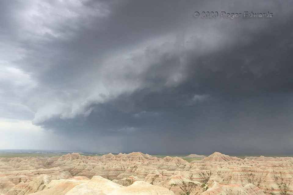
[Part 2 of 2]  As this small segment of the 2020 Great Western Derecho struck, a wall of verifiably severe wind roared up the Badlands from the lower Plains below, further accelerating the intense blast up the bluffs.  This was the last shot before I ran the hundred feet or so back to my vehicle, threw my gear onto car-camping bedding and pillows in the back, and pointed the front into the wind.   It rocked hard, shaking up and down with tremendous gusts, and certainly would have rolled if pointed sideways to the upslope-channeled, open-exposure current.  I had been in the eyewalls of two hurricanes, and without the skill to offer a specific estimated speed, can say confidently the winds were similar to the west eyewall of Hurricane Dennis.  The closest instrumented gust measurement was 92 mph at Cactus Flat, to the southeast, after going behind the apex of the shelf cloud at left.  This was just my dramatic little slice of the event.   The broader derecho goes on record as among the most intense ever recorded.  The event swept in a daylong rampage from southern Utah to North Dakota with over 400 reports of severe wind—most of them measured.  Over 40 of those gusts were significant (74 mph or greater). [Back to Part 1]

4 NW Interior SD (6 Jun 20) Looking S
43.7883, -102.0323

Filed Under: Gallery of Outflow Tagged With: arcus, Badlands, clouds, convection, dust, geology, Great Plains, Interior, landscapes, National Parks, outflow, shelf cloud, South Dakota, storms, thunderstorms, weather

Previous: Rotation Undercut
Next: Sunset at Home

About

Welcome to SkyPix, an online photo book of clouds, weather and water by Roger Edwards. As in a printed coffee-table book, every image has its own page with a unique story. After all, meaningful photography is much more than just picture-taking; it is visually rendering a moment in place and time from a perspective like none other. As a scientist and an artist, I hope my deep passion for the power and splendor of our skies and waters shines through in these pages. If you are a cloud and weather aficionado, outdoor enthusiast, outdoor or nature photographer, art lover, or anyone who craves learning, enjoy...

More

Further images from this photographer may be found at:
Roger Edwards Image of the Week
Roger Edwards Digital Galleries
Storms Observed Chase BLOG

Copyright © 2025 ROGER EDWARDS SKYPIX.PHOTOGRAPHY ALL RIGHTS RESERVED. · Design by INSOJOURN Design and Images · WordPress · Log in