SkyPix

A digital photographic storybook of clouds, weather and water by Roger Edwards.

  • Home
  • Newest Posts
  • Galleries
    • Aerial
    • All Hail
    • Burnscapes
    • Daytime Lightning
    • Floods
    • Fog and Mist
    • Gallery of Outflow
    • Hurricane Andrew
    • Mini Cloud Atlas
    • Night Lightning
    • Mostly Okie Winters
    • Sunsets and Sunrises
    • The Majestic Supercell
    • Tornadoes
    • Unusual Weather Damage
    • Visual Effects
    • Wall Cloud Wall
    • Water Works
  • About
  • F.A.Q.
  • Contact

Backshear Catching Rays

2020-06-17 By Roger Edwards

Backshear Catching Rays (Cb at sunset))

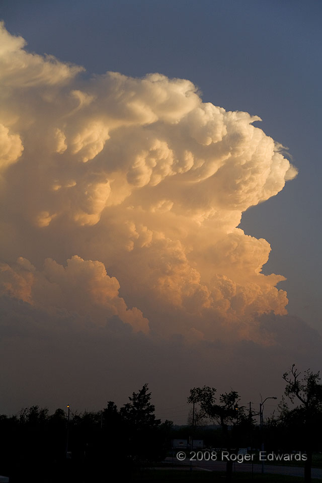
A lone and young supercell, vigorous convection propelling a backshearing cloud mass westward, dominated the southern sky.  On a day with strong capping and questionable storm development potential, this sunset special was the only daylight storm to form in a 400 mile long swath of dryline between central Oklahoma and south Texas.  This storm would last just long enough to cause a few reports of damaging hail near 2 inches in diameter, before dying quickly in stabilizing evening air southeast of Norman.  For all the advances in severe weather prediction that have been made in the last couple decades, selecting the specific location and timing of storm development still may be the most elusive nugget of understanding, and the biggest source of uncertainty (by far) in short-term forecasting.  If not, the hardest thing to forecast with a storm is when it will dissipate.

Norman OK (21 Apr 8) Looking S
35.1819, -97.4411

Filed Under: Sunsets and Sunrises, The Majestic Supercell Tagged With: backshear, clouds, convection, cumulonimbus, mammatus, National Weather Center, Norman, Oklahoma, storms, sunsets, supercells, thunderstorms, University of Oklahoma, weather

Previous: Sunset Light through Wavy Supercell
Next: Inflow-Outflow Interface

About

Welcome to SkyPix, an online photo book of clouds, weather and water by Roger Edwards. As in a printed coffee-table book, every image has its own page with a unique story. After all, meaningful photography is much more than just picture-taking; it is visually rendering a moment in place and time from a perspective like none other. As a scientist and an artist, I hope my deep passion for the power and splendor of our skies and waters shines through in these pages. If you are a cloud and weather aficionado, outdoor enthusiast, outdoor or nature photographer, art lover, or anyone who craves learning, enjoy...

More

Further images from this photographer may be found at:
Roger Edwards Image of the Week
Roger Edwards Digital Galleries
Storms Observed Chase BLOG

Copyright © 2025 ROGER EDWARDS SKYPIX.PHOTOGRAPHY ALL RIGHTS RESERVED. · Design by INSOJOURN Design and Images · WordPress · Log in