SkyPix

A digital photographic storybook of clouds, weather and water by Roger Edwards.

  • Home
  • Newest Posts
  • Galleries
    • Aerial
    • All Hail
    • Burnscapes
    • Daytime Lightning
    • Floods
    • Fog and Mist
    • Gallery of Outflow
    • Hurricane Andrew
    • Mini Cloud Atlas
    • Night Lightning
    • Mostly Okie Winters
    • Sunsets and Sunrises
    • The Majestic Supercell
    • Tornadoes
    • Unusual Weather Damage
    • Visual Effects
    • Wall Cloud Wall
    • Water Works
  • About
  • F.A.Q.
  • Contact

Backbuilder

2019-02-22 By Roger Edwards

Backbuilder (A Squall-Line Tornado)

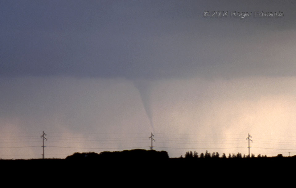
This tornado caught us somewhat by surprise. Instead of being spawned by a supercell of some sort, it developed near what was then the tail end of a squall line, as the line was “backbuilding” southwestward through constant formation of new cells. This process is called discrete propagation, and if the environment is just right (rich in boundary-layer cyclonic vorticity), can spawn such non-supercell tornadoes on rare occasion. The most notorious example of a tornado from discrete propagation or backbuilding was the F5 Jarrell, TX tornado of 27 May 97, which formed that way in a storm that later became a supercell as the tornado was in progress. Jarrell was the most extreme example, however. Most discrete-propagation events produce no tornadoes at all, and those that do form usually are not even as well-developed as the one in this film slide. Another cell, forming just to its SW, already was dumping rain around the tornado, which disappeared less than a minute later.

3 NW Duncombe IA (11 Jun 4) Looking SW
42.5158, -94.0205

RADAR

Filed Under: Tornadoes Tagged With: clouds, convection, Duncombe, Fort Dodge, Iowa, multicell, squall line, thunderstorms, tornado, weather

Previous: Papakolea “Green Sand” Beach Cliffs
Next: Fort Floor Stalagmite

About

Welcome to SkyPix, an online photo book of clouds, weather and water by Roger Edwards. As in a printed coffee-table book, every image has its own page with a unique story. After all, meaningful photography is much more than just picture-taking; it is visually rendering a moment in place and time from a perspective like none other. As a scientist and an artist, I hope my deep passion for the power and splendor of our skies and waters shines through in these pages. If you are a cloud and weather aficionado, outdoor enthusiast, outdoor or nature photographer, art lover, or anyone who craves learning, enjoy...

More

Further images from this photographer may be found at:
Roger Edwards Image of the Week
Roger Edwards Digital Galleries
Storms Observed Chase BLOG

Copyright © 2025 ROGER EDWARDS SKYPIX.PHOTOGRAPHY ALL RIGHTS RESERVED. · Design by INSOJOURN Design and Images · WordPress · Log in