SkyPix

A digital photographic storybook of clouds, weather and water by Roger Edwards.

  • Home
  • Newest Posts
  • Galleries (Menu)
    • Aerial
    • All Hail
    • Burnscapes
    • Daytime Lightning
    • Floods
    • Fog and Mist
    • Gallery of Outflow
    • Hurricane Andrew
    • Mini Cloud Atlas
    • Night Lightning
    • Mostly Okie Winters
    • Panoramics
    • Sunsets and Sunrises
    • The Majestic Supercell
    • Tornadoes
    • Unusual Weather Damage
    • Visual Effects
    • Wall Cloud Wall
    • Water Works
  • About
  • F.A.Q.
  • Contact

Arnett Tornadic Supercell

2025-08-18 By Roger Edwards

Arnett Tornadic Supercell
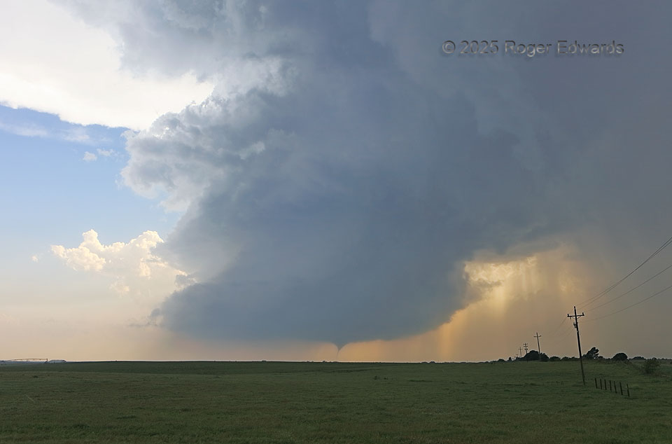
Within a minute or less after this tornado started, this obviously was shaping up to be an epic scene, a fulfillment of a storm observer’s dream, with an organizing tornado beneath a well-defined, High Plains supercell.  Contrary to some social -media claims, it was not a true low-precipitation (LP) storm at any point during this tornado!  Just because one can see all the structure doesn’t mean it was LP.  In this case, it simply was highly visible, with good separation between the heaviest precip and the updraft.  In fact, plenty of moderate to locally heavy rain with embedded severe hail was falling already to the right, in the forward-flank core, and extending back into the rear flank.  Archived radar, which anyone can download and examine now, and which I was watching in the field, resoundingly verified this.  As the supercell swirled ever closer, it continued dropping sporadic hail up to two inches across on my location, and dense rain and hail further into that forward-flank core, while becoming even better defined in a structural sense.

6 E Arnett OK (18 May 25) Looking W
36.1369, -99.6679

Filed Under: The Majestic Supercell, Tornadoes Tagged With: Arnett, clouds, convection, Great Plains, landscapes, Oklahoma, storms, supercells, thunderstorms, tornado, weather

Previous: Temporary Falls, Mt. Rainier
Next: Vault Wall

About

Welcome to SkyPix, an online photo book of clouds, weather and water by Roger Edwards. As in a printed coffee-table book, every image has its own page with a unique story. After all, meaningful photography is much more than just picture-taking; it is visually rendering a moment in place and time from a perspective like none other. As a scientist and an artist, I hope my deep passion for the power and splendor of our skies and waters shines through in these pages. If you are a cloud and weather aficionado, outdoor enthusiast, outdoor or nature photographer, art lover, or anyone who craves learning, enjoy...

More

Further images from this photographer may be found at:
Roger Edwards Image of the Week
Roger Edwards Digital Galleries
Storms Observed Chase BLOG

Copyright © 2026 ROGER EDWARDS SKYPIX.PHOTOGRAPHY ALL RIGHTS RESERVED. · Design by INSOJOURN Design and Images · WordPress · Log in