SkyPix

A digital photographic storybook of clouds, weather and water by Roger Edwards.

  • Home
  • Newest Posts
  • Galleries
    • Aerial
    • All Hail
    • Burnscapes
    • Daytime Lightning
    • Floods
    • Fog and Mist
    • Gallery of Outflow
    • Hurricane Andrew
    • Mini Cloud Atlas
    • Night Lightning
    • Mostly Okie Winters
    • Sunsets and Sunrises
    • The Majestic Supercell
    • Tornadoes
    • Unusual Weather Damage
    • Visual Effects
    • Wall Cloud Wall
    • Water Works
  • About
  • F.A.Q.
  • Contact

3 Non-Tornadoes!

2023-09-25 By Roger Edwards

3 Non-Tornadoes!

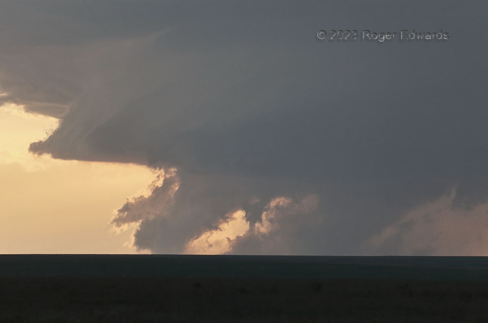
Why show a non-tornado when one can show three at once, from the same storm?  This oddity came about as a distant, high-based supercell dove south-southeastward across a remote part of southeastern Colorado, between the Purgatoire River and the town of Kim.  The skirt-edged wall cloud in the middle to upper part of this shot was real, attending a well-organized midlevel mesocyclone with broad (but not particularly strong, at this time) low-level rotation.  A gentle terrain rise in the many intervening miles between me and the storm truncated a view of any gaps between the cloud lowerings and the ground.  All were tilted southward from top to bottom, in step with outflow from the rear-flank downdraft.  All were behind the wall cloud and mesocyclone, though low contrast makes discerning that difficult for the most funnel-shaped lowering, at right. The small lowering in the middle looks like it could be a tube with scud surrounding it, and a “debris” fan at the bottom. The leftmost lowering is the most obviously scuddy junk.  How did I know none were tornadic?  They weren’t rotating…just translating, right to left, faster than storm motion, in a manner consistent with being outflow-driven.  That was easy.  How did I know?  The very same zoom lens I had attached to a heavy tripod, and was using to shoot, also made a great monocular to observe the features.  Aside from non-rotating scud, other non-tornado types I have in this gallery include outflow dust under a storm base, a dense precip shaft at night, and a real, slowly rotating funnel with unrelated outflow dust in front.

4 NW Pritchett CO (8 Jul 23) Looking W
37.4258, -102.8926

Filed Under: Gallery of Outflow, Mini Cloud Atlas, Wall Cloud Wall Tagged With: clouds, Colorado, convection, deep zoom, fractocumulus, Great Plains, landscapes, mammatus, nontornado, outflow, Pritchett, scud, storms, sunsets, supercells, thunderstorms, wall clouds, weather

Previous: Tornadic Dust and Rain
Next: Golden Glory

About

Welcome to SkyPix, an online photo book of clouds, weather and water by Roger Edwards. As in a printed coffee-table book, every image has its own page with a unique story. After all, meaningful photography is much more than just picture-taking; it is visually rendering a moment in place and time from a perspective like none other. As a scientist and an artist, I hope my deep passion for the power and splendor of our skies and waters shines through in these pages. If you are a cloud and weather aficionado, outdoor enthusiast, outdoor or nature photographer, art lover, or anyone who craves learning, enjoy...

More

Further images from this photographer may be found at:
Roger Edwards Image of the Week
Roger Edwards Digital Galleries
Storms Observed Chase BLOG

Copyright © 2025 ROGER EDWARDS SKYPIX.PHOTOGRAPHY ALL RIGHTS RESERVED. · Design by INSOJOURN Design and Images · WordPress · Log in